LANGTANG PARK
Central Himalaya, NepalThe former Langtang Village, in Langtang National Park, was buried by an earthquake-triggered rockfall. Glacial till filled the valley. The size and scope of the fall created entirely new land, spread across ten square kilometers. Following the devastation of the avalanche, a process of reconstruction was formally initiated but, unlike the event, help was slow and discriminating. The purpose of this account is to shed light on the relations that bind people and place, not to criticize the lack of aid following the earthquake. The extents of the landscape of retreat are multidimensional as villagers participate in a process of healing through everyday acts of design and plants help to restore relationships severed by the earthquake.
A kind of narrative repair that chooses to enlighten, rather than accuse. The ambition is to learn how to approach a vulnerable. Making any sense of the friction challenges research because the Chilean coast.
It took us ten days to reach our destination. The reasons are manifold, including the distance to Kathmandu and the length of the trek itself, changes in altitude, and intermissions brought on by illness. In the Himalayas, distance cannot be measured in days, miles, or altitude so much as periods of rise and fall, a reminder that “site” is inconsequential until it is associated with direct experience. In this case, it was the experience of getting there, a visceral reminder of the meaning of remote; from the Latin remotus, meaning a far off, distant place. Remoteness, while physical, often underlies the intellectual gap created between cultures—a gap that conflates the remote with disconnection and creates exoticism. When considering remoteness up close, it grows to encompass earthly matters. For instance, the ups and downs register distance by forging a very different relationship to terrain than the one I am familiar with: gentle foothills are bounded by jagged mountains and overlap with rangelands. Each elevation between mountain and valley extends in an almost parallel direction from East to West in the Himalayas, as folds of topography mark everyday life for villagers and herders. For those who inhabit the land, borders are drawn in verticals, an agitation to the planar map and the round globe, because Nepal is a country perched at elevation. Its borders are more like a shadow cast by the Himalayas.
What I learned from my walk to Langtang is that studying maps to gauge altitude and distance, or training for endurance are only helpful distractions to the fact that there is no way to sufficiently prepare for being in a particular place at a particular time. In Nepal, time broadens and expands to include the cadence required to reach high-hard ground, snow squalls, landslides, and deeply incised rivers that swell with geologic rules. The traveler cannot take a straight line, measure distance, or anticipate the topography around each bend. Rather, she trips, marches, bounds, and crawls. Forget GPS technology or landmarks, nothing looks the same on ascent or descent, as fog hangs in surprising ways that blurs and reveals the journey. Wayfinding becomes relative at a certain altitude. Still, it is hard to get lost, because there is only one path well-traveled, a foot pass that curves along a narrow range. The alternative is usually a steep downward slope on one side, or the loose remnants of a landslide on the other, a stark reminder to stay the course. A pasture is a relief, a wide course where feet and mind wander. It is an entirely new kind of walking, as Jamaica Kincaid remarks with respect to her own trek in Nepal, “As much as I looked down to see where I should place my feet, I looked up to see the sky because so much of what happened up there determined the earth on which I stood.”
The Abode of Snow
It took us ten days to reach our destination. The reasons are manifold, including the distance to Kathmandu and the length of the trek itself, changes in altitude, and intermissions brought on by illness. In the Himalayas, distance cannot be measured in days, miles, or altitude so much as periods of rise and fall, a reminder that “site” is inconsequential until it is associated with direct experience. In this case, it was the experience of getting there, a visceral reminder of the meaning of remote; from the Latin remotus, meaning a far off, distant place. Remoteness, while physical, often underlies the intellectual gap created between cultures—a gap that conflates the remote with disconnection and creates exoticism. When considering remoteness up close, it grows to encompass earthly matters. For instance, the ups and downs register distance by forging a very different relationship to terrain than the one I am familiar with: gentle foothills are bounded by jagged mountains and overlap with rangelands. Each elevation between mountain and valley extends in an almost parallel direction from East to West in the Himalayas, as folds of topography mark everyday life for villagers and herders. For those who inhabit the land, borders are drawn in verticals, an agitation to the planar map and the round globe, because Nepal is a country perched at elevation. Its borders are more like a shadow cast by the Himalayas.
What I learned from my walk to Langtang is that studying maps to gauge altitude and distance, or training for endurance are only helpful distractions to the fact that there is no way to sufficiently prepare for being in a particular place at a particular time. In Nepal, time broadens and expands to include the cadence required to reach high-hard ground, snow squalls, landslides, and deeply incised rivers that swell with geologic rules. The traveler cannot take a straight line, measure distance, or anticipate the topography around each bend. Rather, she trips, marches, bounds, and crawls. Forget GPS technology or landmarks, nothing looks the same on ascent or descent, as fog hangs in surprising ways that blurs and reveals the journey. Wayfinding becomes relative at a certain altitude. Still, it is hard to get lost, because there is only one path well-traveled, a foot pass that curves along a narrow range. The alternative is usually a steep downward slope on one side, or the loose remnants of a landslide on the other, a stark reminder to stay the course. A pasture is a relief, a wide course where feet and mind wander. It is an entirely new kind of walking, as Jamaica Kincaid remarks with respect to her own trek in Nepal, “As much as I looked down to see where I should place my feet, I looked up to see the sky because so much of what happened up there determined the earth on which I stood.”
1
Jamaica Kincaid, Among Flowers: A Walk in the Himalaya (London: Picador, 2020),
23. Notably, the author traveled to Nepal to collect seeds for her garden in Vermont.
Kincaid’s prose is always arresting, but reading her account prior to the trip did little to prepare me for the incomparable experiences that were both so absorbing and so unprecedented.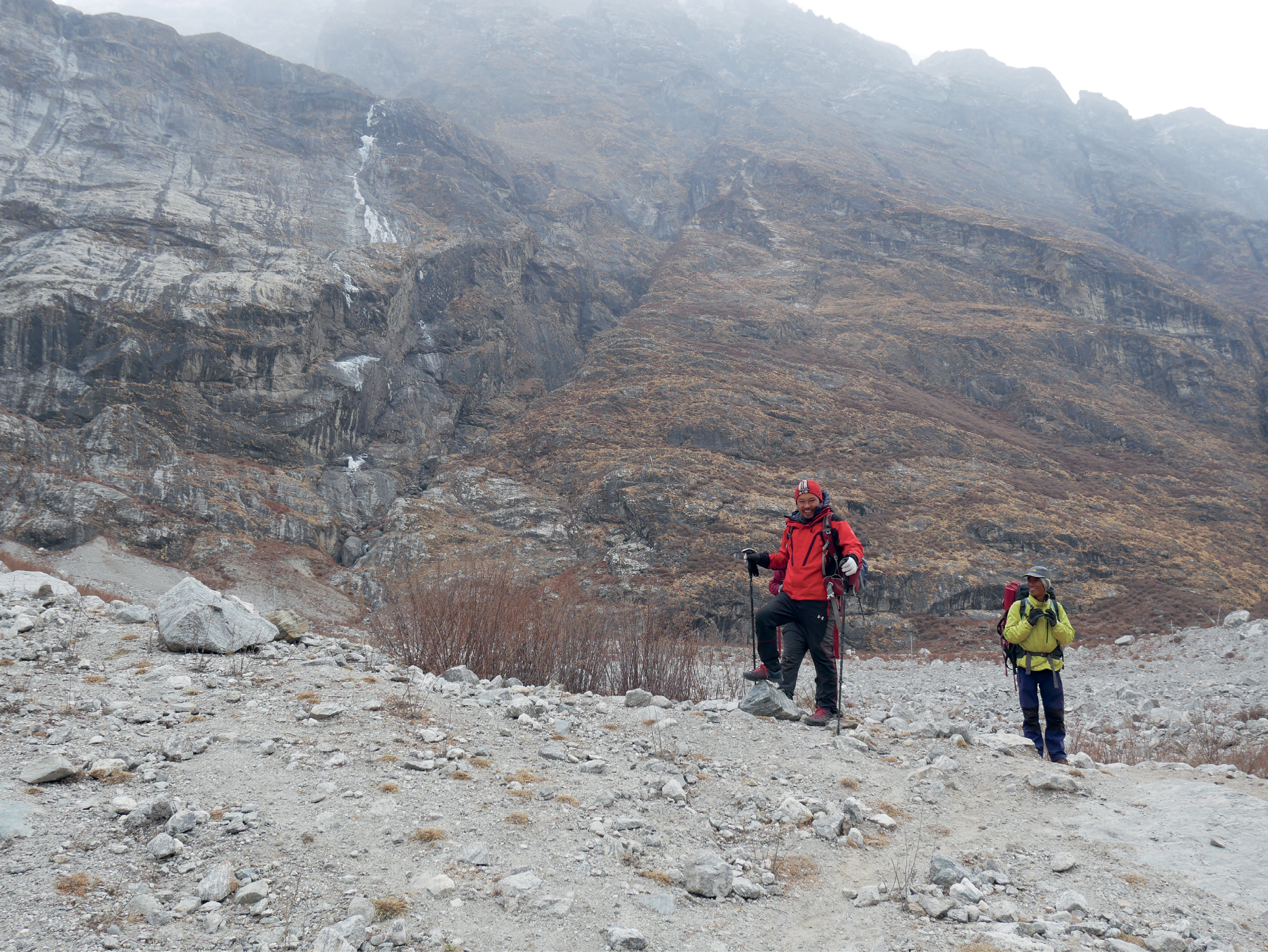
The entire country of Nepal is situated between the collision zone of the Indian and Eurasian tectonic plates, which shift underfoot as the two landmasses move closer and closer. Each peak, mountain, and hill are a geophysical reminder that the heights of dramatic landscapes are the layered result of relatively young, recent events in earth’s history. Paleozoology reveals that about 65 million years ago the slow friction of plate movement pushed the seabed of the Tethys to the high mountain ranges. Movement continued in several epi- sodes, and continues today as the Indian plate is thrusting north about two centimeters every year, causing the Himalayas to rise about five milimeters each year. While this broad movement is beyond everyday experience, there are localized clues along the steep slopes: shallow slides, rock falls.
During one of our longest days walking uphill, I asked our guide and friend Babu when we might see some flatter terrain. Although I needed to catch my breath, I was not yet unaware that I was suffering altitude sick- ness. He motioned ahead and told me it was around the corner: “Coming, coming.” After another hour or so, I asked him again. This time Babu replied: “This
is flat.” There was a long pause between us. As we stood on a steep slope, he said, as if I had not understood: “Nepali flat.”